The worst-case scenario of riding UTV is getting lost in the jungle. But with the best GPS for UTV trail riding, you have nothing to worry about as you’ve got the perfect device to help you navigate your way easily with your UTV.
It is one of the best UTV accessories that you have to keep in your vehicle whenever you are riding the all-terrain vehicle. When it comes to finding the right track for off road drive, gps is the perfect option for any scenario.
Contents
Best Gps for UTV Trail Riding Buyer’s guide
There are essential things that you ought to consider whenever you find yourself confused on the right GPS you should select for your UTV. Here are some of the things you should consider.
The accuracy of the mapping
When you are driving your UTV, you need a working GPS that will tell you things ahead of you, such as the nature of the road and how you should navigate. It is why you should consider an off-road GPS that can offer accurate terrain mapping.
A quality GPS with a high level of accuracy should be able to map out unsealed roads, geographical features on the terrain, contour lines and also notify you of things ahead such as rocky terrain, swampy land, cliffs, river beds and so on.
Battery life span
While you should consider the design and features of the GPS, one of the things you should also consider is the battery life of the Gps. It will be disastrous to find your GPS device with a flat battery when you get lost in the jungle.
So, you should consider the one with good battery life span, learn how to recharge, the hours it can run on a full charge and the time it takes to get fully charged.
Placement
You should ask yourself where you intend to put the GPS in your UTV. You either select from the portable unit or in-dash unit. You should consider the style of your UTV and choose the one that is of great interest to you.
Note: the placement determines your experience with the device, which is why you need to consider that and choose the one that is convenient for you while riding the UTV.
Screen size
One of the factors you should consider is the size of the screen of the GPS you want to buy. The brightness and how visible the features are on the device. If the screen is small, it might be quite difficult to have a smooth experience with the device.
Therefore, it is important that you choose the one with a large screen where you can easily see things clearly without hassles.
Durability
Yes! It is part of the factors. You need to be sure you are getting a quality product that has the capacity to withstand your daily trail riding demand.
Best Gps for UTV Trail Riding
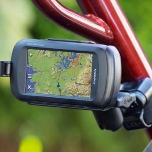
The Magellan TRX7 CS Dual Mount Trail is sure one of the GPS trackers you should never overlook as it is specially designed for outdoor use, such as with UTVs and some other utility vehicles. It is your best road angel, as it is equipped with all to guide you rightly.
The price of the GPS is on the high side, but it is a great bargain considering all its features and the engineering behind its construction. The TRX7 CS comes preloaded with over 115,000 4WD, ATV, Motorcycle, and Snowmobile Trails.
The OHV routes from forest and public lands make it an excellent choice for UTVs and utility vehicle riders. One of the right sides of the GPS is its lifetime map and software updates. Also, it has built0in a 5MP camera with LED flash.
Pros
Dual ram mount for installation on any vehicle
Lifetime map and software updates
Preloaded with over 115,000 4WD, ATV, motorcycle trails
Easy to operate and read
Cons
Slow operational system
- Turn-by-turn trail and street navigation. Free lifetime map and software updates
- Built-in 5MP camera with LED flash. Ram Dual mount. Free lifetime map and software updates
- Pre-loaded with over 115, 000 4WD, ATV, motorcycle, and snowmobile trails. Ram Dual mount
- Hi-res (10M) 2D TOPO and 3D baseman of the USA and Canada with lifetime free updates
- Track recording and community Publishing, Crowdsourced track database, and one-touch social sharing. Contact the Magellan OHV product team for questions and support: [email protected] trxsuport.Magellangps.Com
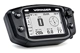
Trail Tech 912-2010 Voyager Stealth Black Moto-GPS Computer
Getting Trail Tech 912-2010 Voyager Stealth Black Moto-GPS Computer is a great bargain for whosoever that wants to hit the trail with little or knowledge of the trail. It is designed for the off-road, which makes it a great fit for ATVs, motorcycles, and four-wheel drives.
It takes an accurate reading of the trail and ensures you are always on track. It fits Grizzly 450/700 08-12, Raptor 660 01-05, Raptor 700 06-12, YFZ450 04-09 and 12, YFZ450R/X 11-12, Yamaha Banshee 87-09 and Suzuki LT-Z400 02-08.
You can always rely on it for an accurate track of your trail, even if you find yourself in the toughest terrain. On the display screen, you have back-lit that enhances the visibility, and there you can easily see data of the speed, compass, distance covered, ambient, temperature of the engine, maps, and many more.
Pros
Perfect for 4-wheel drive, UTV, and other vehicles
Offers accurate reading
Users can easily customize the GPS
Data displays on the screen for users
Cons
None
- Fits: Yamaha Banshee 87-09, Grizzly 450/700 08-12, Raptor 660 01-05, Raptor 700 06-12, YFZ450 04-09 and 12, YFZ450R/X 11-12; Suzuki LT-Z400 02-08; Kawasaki KFX400 02-08; Bombardier DS650 00-08
- The one and only GPS designed and manufactured for off-road; whether you ride motorcycles, ATVs, snowmobiles or 4 wheel drives, Voyager is your unit
- Back-lit 240 x 400 WQVGA LCD screen displays: GPS speed, distance, compass, altitude, ambient and engine temperature, maps, customizable user screens
- Track manager CD allows you to view, organize, edit and share entire trail systems in 3D while the waterproof MicroSD card lets you download and share trail maps online
- Smart data logging: when your engine stops so does the GPS trail logging - eliminating random data points from your track when you're not moving, Voyager provides clear, accurate tracks even in the toughest terrain
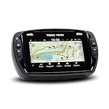
Trail Tech 922-125 Voyager Pro Universal UTV Powersports GPS
The Trail Tech 922-125 Voyager Pro Universal UTV Powersports GPS Trail Tech 922-125 Voyager Pro Universal UTV Powersports GPS offers the best and accurate reading for tracks and trails. It is designed for Off-road with 4 inches color touchscreen anti-glare display.
The engineering design of the GPS ensures that it is sealed and rated IP67 for anti-dust and water intrusion to prevent the components from damages. Also, it comes color navigation screen where you can see all that the GPS has to transmit.
GPS allows messaging, media controls, and phone calls. With it, you can easily track the speed, weather temperature, distance, elevation, and voltage. Furthermore, all you should expect from the kit includes a head unit, CVT temperature sensor, power lead, vehicle charger, ignition sensor, buddy tracking antenna, ram column mount, and dock.
Pros
Anti-dust and water intrusion design
Tracks all information for all trails
It is Bluetooth enhanced
Cons
None
- Off-road GPS with 4 inch color touchscreen anti-glare display, sealed and rated IP67 for anti dust/water intrusion
- Color navigation screen, topography maps and hill shading, supports tracks, routes and waypoints
- Tracks speed in mph using the GPS or wheel sensor; displays speed, temperature, distance, elevation and voltage
- Buddy tracking displays the current location of up to 20 members of your ride group on the map screen
- Bluetooth enabled for intercom, phone dialing, messaging and media controls
Garmin Zumo 595LM
Looking for a quality GPS and your choice is from any of the best in the industry, then you should consider Garmin Zumo 595LM. It is a great navigation tool for all UTV and utility vehicle riders. The rugged design of the GPS sees to it that it can stand the test of time.
It has a sunlight-readable 5-inch dual-orientation touchscreen with a rugged design that can handle the harshest weather condition. It easily finds curvy and hilly roads, and it doesn’t just find but alerts riders of that which is ahead of them.
The operation of the GPS is hand free, and it has hand-free calling and smartphone notifications shown on the screen. Mind you, you need an app for the hand-free operation, and you have to purchase it. Some of its positives include being able to control music from your mp3 player or smartphone.
Pros
Gets riders alert of things ahead
Comfy and lightweight
Handy and well designed with quality material
Cons
None at the moment

- Premium motorcycle GPS for new adventures in riding
- Glove- , sunlight-readable 5-inch dual-orientation touchscreen with rugged design for harsh weather (IPX7)
- Garmin Adventurous Routing finds curvy or hilly roads; limits major highways
- Rider alerts for sharp curves, state helmet laws, speed cameras (not available in all regions) and more
- Bluetooth for hands-free calling and smartphone notifications right on your zūmo screen (requires Bluetooth-compatible helmet, headset or smartphone (sold separately) and the free Smartphone Link app)
Trail Tech 912-301 Voyager Stealth Black Moto-GPS Computer
The Trail Tech 912-301 Voyager Stealth Black Moto-GPS Computer is another dynamic choice among quality GPS you should consider for your adventure on different trails. One thing is assured with the GPS, and that is the accurate reading of the tracks even when you find yourself in the toughest terrain.
It is designed for off-road use and very perfect for ATVs, UTVs, snowmobiles and some other 4-wheel drives. It gives clear details of your track on the LCD screen displays such as the speed, distance, compass, altitude, engine temperature, maps, and ambient.
The GPS fits Suzuki RMZ 250/450 08-12, DRZ400/KLX400 00-11 radiator screw sensor. It has all that is required to offer you the best trail instruction needed to get to your destination without losing track or getting lost during the adventure.
Pros
Gives clear and accurate track reading
Very simple to use
Lightweight and handy
Compatible with mobile devices and computer
Cons
None at the moment
- Fits: Suzuki RMZ 250/450 08-12, DRZ400/KLX400 00-11 radiator screw sensor
- The one and only GPS designed and manufactured for off-road; whether you ride motorcycles, ATVs, snowmobiles or 4 wheel drives, Voyager is your unit
- Back-lit 240 x 400 WQVGA LCD screen displays: GPS speed, distance, compass, altitude, ambient and engine temperature, maps, customizable user screens
- Track manager CD allows you to view, organize, edit and share entire trail systems in 3D while the waterproof MicroSD card lets you download and share trail maps online
- Smart data logging: when your engine stops so does the GPS trail logging - eliminating random data points from your track when you're not moving, Voyager provides clear, accurate tracks even in the toughest terrain
The Garmin eTrex 20x is another kind of GPS tracker that you should consider for your off-road adventure. It is the perfect choice for you if you do not have the simplest idea or information about the route. It has WAAS enabled GPS receiver and GLONASS support.
The eTrex is viable and very effective in locating your position quickly and accurately, thereby maintaining its location even in heavy cover and deep canyons. It has 3.7 GB internal memory and a microSD card slot and lots of other features such as TOPO 24K, HuntView, BlueChart g2, City Navigator NT, and BirdsEye Satellite Imagery.
Also, it boasts of 2.2” 65K color sunlight-readable display screen where you get to see the data of all that you have to know about the trail. The GPS keeps you informed of all that is ahead of you and helps you in making the right decision.
Pros
Very easy to use
Keeps you informed
Lightweight and durable
Cons
None at the moment
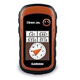
- UPGRADED DISPLAY - Features a 2.2” 65K color sunglight readable display offering increased resolution (240 x 320 pixels)
- LOAD MORE MAPS - Large 3.7 GB of internal memory and microSD card slot lets you load a variety of maps, including TOPO 24K, HuntView, BlueChart g2, City Navigator NT and BirdsEye Satellite Imagery (subscription required)
- PRELOADED BASEMAP - Includes a worldwide basemap with shaded relief. Display size:1.4 x 1.7 inches
- KEEP YOUR FIX - With its high-sensitivity, WAAS-enabled GPS receiver, HotFix satellite prediction and GLONASS support, eTrex locates your position quickly and precisely and maintains its location even in heavy cover and deep canyons
- Included Components: Documentation
Garmin GPSMAP 64st, TOPO U.S. 100K with High-Sensitivity GPS and GLONASS Receiver
Another one on this list from Garmin is the Garmin GPSMAP 64st. It comes handy and very simple to operate. It has enough memory space of 8 GB to store data and keeps you always informed and on the right track. It is not heavy but lightweight, and that makes it safe to move from one place to another.
The GPS works with the help of the dual battery system, which makes use of 2 traditional AA batteries. It can also make use of rechargeable ones to save you the cost of getting battery frequently. It is very accurate with a map and other things needed to get you on the right course.
Apart from the primary assignment, which is to get you on the right trail, it has added features that include the ant+ sensors, such as heart rate monitor, temperature sensor, and speed/cadence. It can easily connect with mobile devices using the Garmin connect app.
Pros
Compatible with mobile devices
Very accurate
Uses rechargeable battery
Lightweight and durable
Digital camera
Cons
You need the Garmin app to connect to your mobile devices
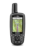
- Sunlight Readable 2.6 inches color display. Display size : 1.43 x 2.15 inches and 2.6 inch diag (6.6 centimeter). Battery life : 16 hours. Water rating IPX7.Control Method:Touch.Special Feature:bluetooth.
- Expanded Internal Memory 8GB.Display resolution 160 x 240 pixels. Interface: high speed USB and NMEA 0183 compatible
- DUAL BATTERY SYSTEM Use with 2 traditional AA batteries (best with Polaroid AA batteries), or the optional rechargeable NiMH battery pack that can be charged while inside the device.Weight 8.1 ounce (230 grams) with batteries
- Receive Smart Notifications* and pair with optional ANT+ sensors, such as heart rate monitor, Tempe temperature sensor, speed/cadence, or use to control your VIRB action camera (64s/64st only)
- Wirelessly upload data to Garmin Connect and view on smartphone, plus share activities as they happen with Live Track (64s/64st only). 3 axis compass with barometric altimeter.Routes:200
Garmin GPSMAP 64SC, Rugged Handheld with GPS/GLONASS, Wireless Connectivity and Digital Camera
The last on the list is also one from Garmin known as Garmin GPSMAP 64SC. It comes with high tech features such as a digital camera, GLONASS settings, and wireless connectivity with mobile devices. It is an amazing piece for outdoor adventure.
The display screen comes with users’ interest as you can easily see the data on the screen even during sunlight conditions. It has 4GB internal memory, uses a dual battery, and can also use the rechargeable NiMH battery pack.
It is very strong, reliable, and durable. It also measures the heart rate, temperature, and other things apart from directing you on the trail. It is the best you can rely on instead of google maps on the phone.
Pros
Lightweight and handy
Measures heart rate
Compatible with mobile devices using the Garmin app
Cons
None

- Sunlight-Readable 2.6" color display
- Expanded Internal Memory 4GB
- DUAL BATTERY SYSTEM Use with 2 traditional AA batteries, or the optional rechargeable NiMH battery pack that can be charged while inside the device.Weight 8.1 oz (230 g) with batteries
- Receive Smart Notifications* and pair with optional ANT+ sensors, such as heart rate monitor, Tempe temperature sensor, speed/cadence, or use to control your VIRB action camera (64s/64st only)
- Wirelessly upload data to Garmin Connect and view on smartphone, plus share activities as they happen with Live Track (64s/64st only)
Satellite Communicator – Never Get Lost

- 100 percent global Iridium satellite coverage enables two way text messaging from anywhere (satellite subscription required)
- Trigger an interactive SOS to the 24/7 search and rescue monitoring center
- Track and share your location with family and friends. Water rating : IPX7. Battery : Rechargeable internal lithium ion
- Pair with mobile devices using the free earthmate app for access to downloadable maps, U.S. NOAA charts, color aerial imagery and more
- In reach explorer+ device adds preloaded Delorme topo maps with onscreen GPS routing plus built in digital compass, barometric altimeter and accelerometer

- Small, rugged, lightweight satellite communicator enables 2 way text messaging using the 100 percentage global Iridium network (satellite subscription required).Special Feature:Bluetooth.
- Trigger an interactive SOS to the 24/7 search and rescue monitoring center (satellite subscription required). Display size-0.9 x 0.9 inch
- Access downloadable maps, U.S. NOAA charts, color aerial imagery and more by using the free Garmin Earthmate app and compatible devices
- Optional inReach weather forecast service provides detailed updates directly to your inReach Mini or paired device, basic and premium weather packages available
- Send and receive inReach messages through compatible Garmin devices, including connected wearables and handhelds. Display resolution: 128 x 128 pixels

- SYNC WITH BLUETOOTH: Connect to SpotX to cellphone so you can communicate with family or even search and rescue; Use as a standalone communication device with it's own dedicated US mobile number to receive messages
- PEACE OF MIND: Send S.O.S. to 24/7 Search & Rescue service, message back and forth about the nature of your emergency, receive confirmation when help is on the way; Message any cell number or email address virtually anywhere
- GLOBALSTAR SATELLITE & SPOT products use GPS to determine location and transmit GPS coordinates to others; SPOT users can notify friends, family or emergency rescue their exact GPS coordinates
- WHAT'S IN THE BOX: SpotX Device, strap and carabiner, micro usb data/power cable, quick start guide, SOS mirrored sticker, warranty card and kickstand
- PURCHASE, ACTIVATE, EXPLORE: Grab a Spot X 2-way Satellite Messenger; Activate by selecting your service plan; Get out there and explore the world with peace of mind
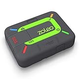
- 🌎ZOLEO GLOBAL TWO-WAY SATELLITE COMMUNICATOR: Rugged, GPS location-aware and Iridium satellite based, the ZOLEO device links with the free ZOLEO app on your smartphone to keep you connected when outside cell coverage. Monthly subscription required: $20, $35 or $50 (25, 250 or unlimited satellite messages) with unlimited check-in, SOS, cell and Wi-Fi messages included. After the initial 3-month commitment, suspend for just $4/mo. Plans available in USA, Canada, Australia, EU but work globally.
- ✉️GLOBAL MESSAGING AS IT WAS MEANT TO BE: ZOLEO extends your messaging coverage to everywhere on earth transmitting over the lowest cost network available (satellite, cellular or Wi-Fi). ZOLEO offers a familiar text messaging experience to and from any SMS text number, email address or another ZOLEO app user. By taking advantage of cellular or Wi-Fi when available and the Iridium network (a truly global satellite network) when it isn’t, ZOLEO offers seamless coverage wherever you go!
- 📲DEDICATED SMS PHONE NUMBER & EMAIL ADDRESS: Your assigned ZOLEO SMS number and email address allows your contacts to initiate messaging with you, as opposed to them waiting to receive a message from you to which they can reply.
- 🆘EMERGENCY ALERTING & MEDICAL ASSIST: If something goes wrong, declaring an SOS ensures your SOS alert and GPS coordinates are sent to the expert 24/7 emergency monitoring service. Your ZOLEO service also includes Medical Assist, a convenient 24/7 chat service for non-emergency medical advice, help locating medical services or replacing medical supplies.
- ✅CHECK-IN & LOCATION SHARING: Check in to let others know you’re OK (using built-in device button or the ZOLEO app) and share your GPS location via messages, check-ins, automated Location Share+ updates or through a secure Share Map URL. Location Share+ (add-on at $6/mo) allows for automatic location sharing at a selected interval and includes a breadcrumb trail viewable on a map.
Conclusion
In reality, people get lost in the jungle while riding UTV and to navigate their way back on track seems impossible to do. It is why you should have the Best GPS for UTV trail riding. With this device, you are assured of smooth navigation even if you miss your track.
Last Updated: September
Last update on 2024-01-01 / Affiliate links / Images from Amazon Product Advertising API